


Hurricane Polo barrels toward Mexico in a remarkably active Pacific season
Hurricane Polo barrels toward Mexico in a remarkably active Pacific season

Chrissy Sexton Wed, September 30, 2026 at 5:05 PM UTC
0
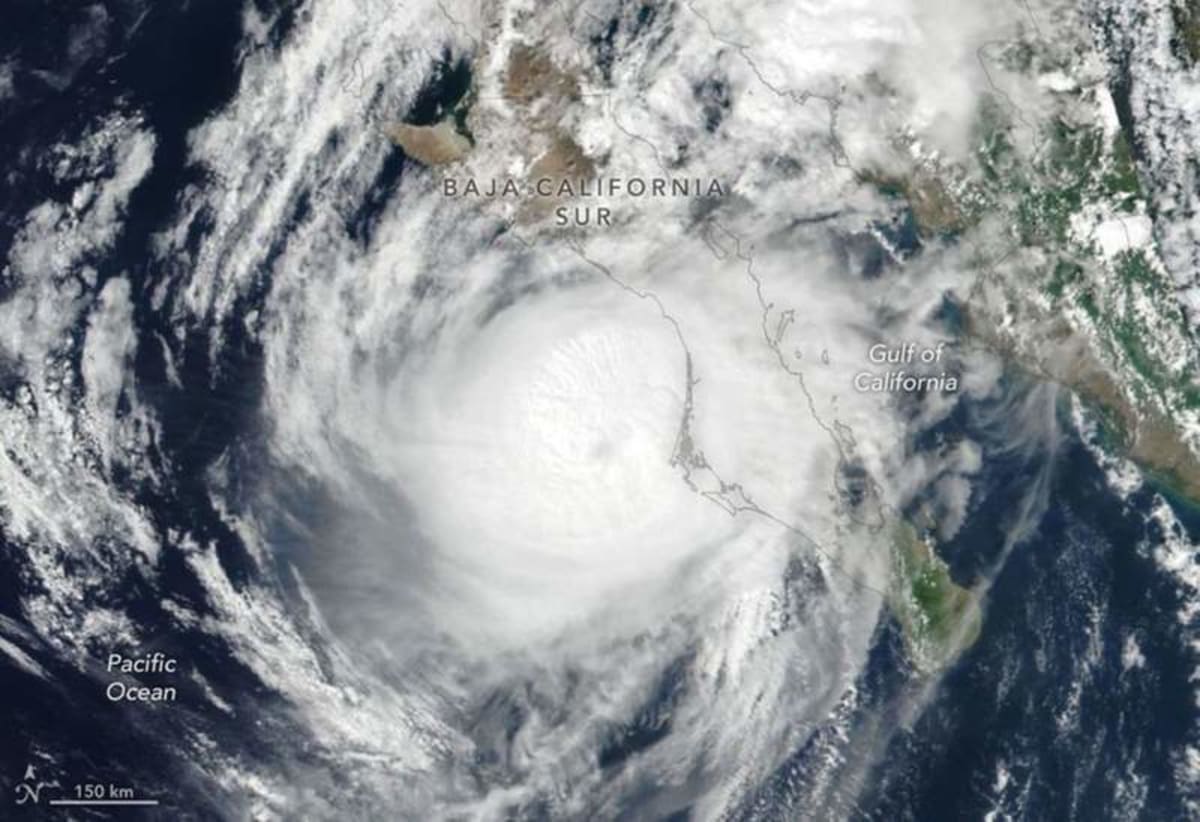
Hurricane Polo approaches the coast of Baja California Sur on September 28, 2026, after rapidly intensifying to category 5 strength days earlier. Credit: NASA Earth Observatory/Lauren Dauphin
Today’s Image of the Day from the European Space Agency shows Hurricane Polo approaching Baja California Sur on September 28.
It was one of several powerful storms crowding the eastern Pacific late in an unusually active hurricane season.
By September 28, the northeastern and central Pacific had produced 20 named storms, including nine hurricanes.
The 1991–2020 average by that point in the season is 13.5 named storms and 7.4 hurricanes.
Polo became the most intense of the latest systems after strengthening at remarkable speed over exceptionally warm ocean water.
Polo races to category 5 strength
Polo underwent extreme rapid intensification before reaching category 5 strength on September 22.
Rapid intensification occurs when a tropical cyclone’s maximum sustained winds increase by at least 35 mph within 24 hours.
Warm ocean water can provide the heat and moisture needed for that kind of explosive development when other atmospheric conditions are favorable.
The hurricane weakened considerably before reaching Mexico.
Polo made landfall in Baja California Sur at about 11 p.m. local time on September 28, according to the National Hurricane Center (NHC).
The agency estimated that it likely came ashore as a category 2 hurricane, still powerful enough to bring destructive winds, storm surge and torrential rain.
A second landfall brings more danger
Polo crossed the Baja California peninsula, moved over the Gulf of California and reached mainland Mexico near Guaymas around midday on September 29.
By then, the system had weakened further. Even a fading tropical cyclone, however, can produce dangerous flooding long after its strongest winds have subsided.
Forecasters warned that heavy rainfall could trigger flash flooding and mudslides in Baja California Sur and Sonora.
Mountainous terrain can make tropical rainfall particularly hazardous because water runs rapidly downhill and saturated slopes can give way.
Coastal areas also faced dangerous winds and storm surge as Polo moved through the region.
Tropical moisture reaches the United States
Polo’s influence was not expected to stop at the Mexican border.
Moisture from the hurricane and its remnants was forecast to combine with moisture associated with Post-Tropical Cyclone Odalys and spread into the southwestern United States and southern Plains over several days.
That influx of tropical moisture raised the threat of additional heavy rain and flooding.
Meanwhile, Tropical Storm Rachel was moving roughly parallel to Mexico’s southwestern coast.
Advertisement
The NHC warned that communities along the coast could experience strong winds, dangerous surf and rip currents as the storm passed offshore.
Hawaii takes another soaking
Farther west, Hurricane Nolo became the third hurricane of the season to pass close to Hawaii.
The storm did not make landfall, but parts of Maui and the Island of Hawaiʻi received more than 12 inches of rain. News reports described flooded roads, fallen trees and landslides.
The Island of Hawaiʻi escaped some of the more serious damage associated with Hurricane Lala in mid-August.
Still, Nolo added another round of disruptive weather during a season that has repeatedly brought tropical systems close to the islands.
The NASA Disasters Program, working with FEMA, is supporting Hawaii’s response and making maps and other data products available through its open-access mapping portal.
A season running well above normal
Storm counts tell only part of the story. Scientists also use accumulated cyclone energy, or ACE, to measure the combined strength and duration of tropical storms and hurricanes during a season.
A long-lived, powerful hurricane contributes much more ACE than a short-lived tropical storm.
As of September 28, ACE in the Northeast Pacific was more than twice the norm, according to data from Colorado State University.
That indicates the basin has not simply produced more named storms than usual. Collectively, its tropical cyclones have also generated an unusually large amount of energy.
El Niño helps set the stage
El Niño has been underway since June, and its influence helps explain why the eastern Pacific has been so active.
The climate pattern is marked by unusually warm surface waters across parts of the equatorial Pacific and can alter winds and weather patterns over a vast area.
In the eastern Pacific, warmer water and relatively low wind shear can create favorable conditions for tropical cyclones to form and strengthen.
Wind shear refers to changes in wind speed or direction with height. Strong shear can disrupt a developing storm, while weaker shear can allow its circulation and thunderstorms to remain organized.
The September 28 satellite view captures the result of those favorable conditions in striking detail.
Polo was bearing down on Baja California Sur while other tropical systems stretched across the Pacific, a crowded scene in a season already running far ahead of its usual pace.
Image Credit: NASA Earth Observatory/Lauren Dauphin
—–
Like what you read? Subscribe to our newsletter for engaging articles, exclusive content, and the latest updates.
Check us out on EarthSnap, a free app brought to you by Eric Ralls and Earth.com.
—–
Source: “AOL Breaking”
